A group of us were saying recently that it was about time that we organised another C+ forum ride in the South Pennines. I was the guy with the local knowledge and mapping software, so I volunteered for the pleasant task of devising the route. I hope that you like what I came up with...
I've kept the distance down to try and encourage more forum members to take part. This is intended to be a social ride, not an endurance challenge and if you are reasonably fit, you are welcome to join us. As with all of my routes, there will be an array of scenic hills to tackle. This kind of thing...
There will be a cafe stop after 48 km, with an optional second one at 75 km on the run back through Hebden Bridge. I expect with the stops, and riding at a sociable pace, that we will average about 15 kph overall. Nobody will be left behind. If anybody wants to test their legs on a climb, fair enough, just wait at the top for the slower riders to catch up please - that includes me!
In fairness, I should point out that this really isn't a route for a novice cyclist, or any rider with an aversion to hills! You will need to be pretty strong to get up some of the steeper climbs on your bike, unless you do what I do and spin your way up in a nice low gear. I should also point out that there are some steep descents too. Riders should be sensible and not plunge down them at unsafe speeds - there are dodgy potholes, tricky gravel patches, and some very stupid Kamikaze sheep in these parts...!
Date: Saturday, 23rd June 2007.
Start/Finish: The Community Centre, Caldene Avenue, Mytholmroyd - ample cheap parking (honesty box with suggested donation). If you come into Mytholmroyd on the A646 from the Hebden Bridge direction, turn right into Caldene Avenue at a set of pedestrian-controlled traffic lights. The Community Centre is on the bend immediately in front of you. If you are coming from the Halifax direction, make sure that you don't turn left up the B6138 by mistake - Caldene Avenue is the next left after that! Map showing Caldene Avenue
Times: Meet up at about 09:40 to be ready for a start at 10:00 prompt. Note: we will only have a short warm-up along the A646 to Luddenden Foot before riding round to Luddenden village for the toughest climb of the day. If anybody fancies a better warm-up by riding up Cragg Road (the 'longest hill in England') before the main ride, just let me know and I'll get to the start early to allow time for that. The road is about 9.5 km long and has around 300 m of climbing.
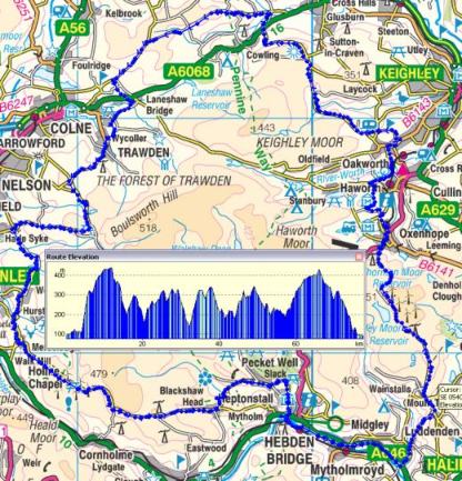
Length of main ride: About 78 km (48 miles).
Total altitude gain: 1,500 m / 2,000 m ('contour counting' method / Memory Map software figure).
Cafe stop 1: Coldwell Activity Centre after 48 km. It will take us about 3 hours to get there, so carry enough food and drink to see you that far. There has always been a nice selection of cakes and sandwiches whenever I've stopped there. I'll give them a ring the day before the ride to make sure that they are open and stocked up!
Cafe stop 2 (optional): Canalside cafe Hebden Bridge after 75 km. It should take us less than 2 hours to get back from the other cafe stop, so you should be okay for food and drink on the second leg.
Start from the community centre at Mytholmroyd, avoiding the parking charges and congestion at Hebden Bridge.
[Optional climb/descent of England's longest hill (Cragg Road to Blackstone Edge) before main ride - if you want to do this let me know. We'd have to allow about 50 minutes for that, which would imply setting off about 08:50]
Short warm-up along A646 to Luddenden Foot.
Turn left and do short climb to Luddenden village.
Climb Stocks Lane to Wainstalls. This has been used for Hill Climb events and, as you'd therefore expect, it is TOUGH! It climbs 200 m in 2 km i.e. it AVERAGES 10%, but is more like 17% in places with a couple of hairpin bends halfway up. That's the toughest climb done with.
Turn left at the top and climb through Wainstalls to Cold Edge. That is an easy climb - about 4% average.
NB - after Cold Edge there is about 1 km of unmade 'dirt' road. It is potholed and gravelly but it is okay to ride on a road bike if you take it easy and watch where you are going. I've done it lots of times and never had a problem. Please don't turn up on a Ł5,000 racing bike and then complain about the state of the road surface! This section is what deters drivers from using the road as a rat-run between Halifax and Oxenhope. They mostly tend to go via Denholme instead. No longer true - the potholes have been filled and the road now has an acceptable tarmac surface.
A nice little lane takes us up to a cattlegrid, then a steep descent to join the A6033 just above Oxenhope.
Descend into Oxenhope, ignoring the first left turn for Penistone Hill. I've found a nicer way over the hill...
Take a left further down at the mini-roundabout in Oxenhope. Descend, then climb back up to Marsh Lane.
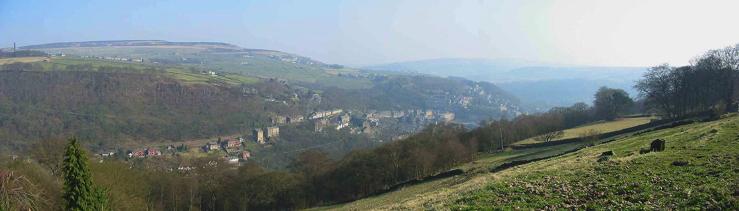
From Marsh Lane, take the lanes over the back of scenic Penistone Hill.
Turn right and proceed to the top of Haworth. Fairly grotty public toilets there if you are desperate!
Take a left and plunge down Mytholmes Lane to the valley bottom, then immediately tackle the stiff little climb up the other side to Oakworth.
Climb undulating lanes to Sutton Moor (great views).
Steep descent to Cowling. Cross the A6068 there.
Stiff climb of Cowling Hill to Black Lane Ends at Hawshaw Moor.
Take a left and descend to Laneshaw Bridge. Cross the main road and take the right for the undulating series of steep little hills through Trawden and up to Clarion House.
Take a left at the crossroads and whizz down to the cafe stop at Coldwell Activity Centre.
[If for any reason anybody wanted to cut their ride short after the cafe stop, they could simply do the (steep!) climb at Thursden pasture then head back home along the Widdop Road]
Bear right 1 km after the cafe stop and take undulating road to Haggate.
Left at crossroads, and take undulating road to Worsthorne. Nice village shop there if anyone wants to buy anything, not that they should need to that soon after the cafe stop!
Little climb out of Worsthorne up to the left turn for Mereclough.
Left at the Kettledrum Inn and drop into the dip. There is a short nasty climb out of the dip, perhaps 200 m at about 17%. After that it is a long easy(-ish) undulating climb up The Long Causeway past the Cliviger windfarm.
From the summit of the climb there is a nice long descent through Blackshaw Head, bearing left down to Jack Bridge.
Short steepish climb of a few hundred metres (length, NOT altitude gain!) to Colden out of the dip at Jack Bridge.
Nice quick descent to Slack Bottom. Yes it IS called that - stop tittering at the back!
Bear left for very quick descent through Lee Wood below Heptonstall. Turn towards Halifax at the turning circle.
Then...
EITHER
Pass straight through Hebden Bridge to finish at Mytholmroyd.
OR
Right at the Co-op for another stop at the canalside cafe. After that we could take the Calder Valley Cycleway to the finish, avoiding the traffic on the busy A646 through HB to Mytholmroyd. The cycleway brings us out onto one end of Caldene Avenue, the community centre being at the other end.
For those of you who might want to do this ride at another time, or just want to take a look at the route using mapping software, here is my detailed route file in GPX format. Google Earth has fantastic high-resolution satellite imagery of most of this area and it is very entertaining to use it to 'fly over' a cycle route. You need a high-speed broadband link and a reasonably quick PC to do this.
Save a copy of the route file on your computer and load it into Google Earth (File/Open, select GPS file type and navigate to the folder where you saved the file). If you adjust the settings in Google Earth carefully (eye level, tilt, tour speed etc.) you can get a good simulated 3-D 'helicopter' view of the route. Don't be alarmed when you 'fall off the edge of the world' - G.E. doesn't yet have high-res imagery of the northernmost part of the route round Cowling!
If you don't understand all this stuff you will have to enlist the help of your friendly neighbourhood computer boffin!